#Advanced Google Map
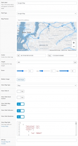
The Advanced Google Map is a collection of new settings added to the ACF Google Map Field that allow developers to have more control over the field behavior. This new settings also include a live preview of the field to show how it will be rendered in the post edit screen.
#Field Settings
| Setting name | Description |
| Map Preview | Live preview of the current map settings |
| Center | Center of the initial map, with latitude and longitude coords |
| Height | The map height |
| Zoom | Initial zoom level, minimum & maximum allowed zoom |
| Maker Image | Custom image upload for the map marker |
| Map Type | Define default map type: Map, Terrain, or both |
| Hide UI | Hide all UI settings (Zoom control, Map Type, Fullscreen & Streetview) |
| Hide Zoom Control | Hide zoom control UI |
| Hide Map Type | Hide map type selection |
| Hide Fullscreen | Hide fullscreen UI button |
| Hide Streetview | Hide streetview UI button |
| Map Style | Apply custom map style in json format. Compatible with Snazzy Maps. |
| API Key | Define Google Maps API key for this map |
#Render on Front-end
You can use the acfe_render_google_map() helper to render any Google Map on the front-end. Usage example:
/**
 * acfe_render_google_map
 *
 * @param  $selector  (optional) The field name/key
 * @param  $post_id   (optional) The post id
 */
acfe_render_google_map([selector = ''], [$post_id = 0]);
You can also pass a list of arguments instead, for more advanced customization.
/**
 * acfe_render_google_map
 *
 * @param  $args  (optional) The render arguments
 */
acfe_render_google_map([$args = array()]);
$args = array(
'selector' => '', // the google map field (optional)
'post_id' => 0, // the post id to retrieve the field (optional)
'id' => '', // the id (for hooks usage)
'class' => 'google-map', // the created map container class
'height' => 400, // default height
'zoom' => 4, // default zoom
'min_zoom' => 2, // minimum allowed zoom
'max_zoom' => 21, // maximum allowed zoom
'center_lat' => 47.127568043756824, // default map position (without marker)
'center_lng' => 8.479324347764278, // default map position (without marker)
'map_type' => 'roadmap', // default map type
'hide_ui' => false, // completely hide UI
'hide_zoom_control' => false, // hide & remove zoomable function
'hide_map_selection' => false, // hide map type selection (satellite...)
'hide_fullscreen' => false, // hide fullscreen icon
'hide_streetview' => false, // hide google streetview function
'disallow_move' => false, // disallow movable map
'style' => false, // custom map style
'markers' => array(), // custom markers
'api_key' => 'ACF_API_KEY_SETTING', // the Google Map API key
);Using the advanced customization, it is possible to retrieve a Google Map field and override specific settings only.
In this example, we retrieve the field my_google_map, and override the “Height” and the “UI” defined in the WP Admin:
acfe_render_google_map(array(
    'selector' => 'my_google_map', // retrieve 'my_google_map'
    'post_id'  => 45,              // from the post id: 45
    'height'   => 600,             // override the height
    'hide_ui'  => true,            // hide the UI
));
It is also possible to simply display a custom Google Map, without any field in the WP Admin. Usage example:
// render a map centered on Paris
acfe_render_google_map(array(
    'center_lat' => 45.7765087,
    'center_lng' => 4.8329508,
    'height'     => 400,
));
Following this logic, you can also add your own custom markers:
acfe_render_google_map(array(
    'class' => 'my-map',
    'markers' => array(
        array(
            'lat' => 46.204653767315,
            'lng' => 6.0758437428116,
            'icon' => '',
            'content' => 'Modal content',
        ),
        array(
            'lat' => 42.25181167315,
            'lng' => -4.6028671946884,
            'icon' => '',
            'content' => 'Modal content',
        ),
    ),
));
Note: If you prefer to render the Google Map by yourself, you can retrieve the field settings such as Height, Marker Image, Map Style etc… with the get_field_object() helper function. See documentation.
